Interacting with the Map
Zooming In or Zooming Out
- Select the Zoom In tool (
 ) or Zoom Out tool (
 ).
). - Click a point on the map and stretch the red selection box over the area you want to zoom in/zoom out on.
Measuring Distance on the Map
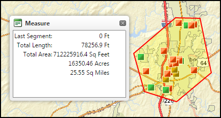
- To start a line, click the Measure button (
 ) and click once on the map. One end of the red line is pinned to the location you selected on the map and the other end is attached to the mouse.
 - Move your mouse around the map with a line attached to it. The Last Segment field in the Measure window displays the measurement changes in real time as you move the mouse.
- To start a new line segment, click once. You can now create a new line segment from a pivot point at the end of your first one. *Note: Make sure your mouse is still before clicking.
- Create new line segments as many times as you need.
- Double-click to end your final segment.
Selecting and Viewing Work Requests, Breadcrumbs, or Users
- Click the Select Tool (
 ).
). - Draw a circle around the unit or units you want to select. *Note: Do not complete the circle as this may cause an error. Once the select items are highlighted, you can let go of the mouse. The selected items are highlighted on the map and information for each item appears in a numbered list in the data grid.
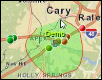
- Click on a number in the Data Grid to zoom in to that item's location.
- Click the Edit button to add comments to or update the status of a Work Item.
- Click the Files button to view any photos or files tagged to the selected Work Item in a separate web page.
![]()
- To clear your selection, click Clear Selection (
 ).
).
Displaying GIS Data on the Map
- Click the GIS Data header in the Sidebar.
- Check or uncheck the boxes to turn a base map on or off.
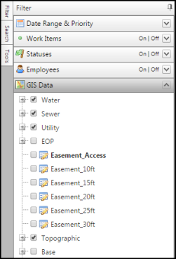
Using the Identify Base Data Tool
The Identify Base Data tool ( ) can reveal data associated with the base maps currently displayed.
- Click the Identify Base Data tool () on the Toolbar.
- Click on the area of the map you would like GIS Data from.
- GIS Data will appear in the Data Grid from the location selected.
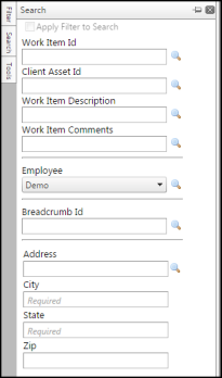
Searching for an Address
- Click the Search Header in the Sidebar.
- Enter your search criteria. *Note: When you search for an address, you must enter the street address, city, and state.
- Click the magnifying glass icon next to the address field to search.
- Click on a number in the Data Grid to zoom in to that location.
- If you want to enter a Work Item, click the Create New Work Item button (
 ) on the toolbar to enter a Work Item for that location.
 - If you want to start a new action, click the Clear Selection button (
 ) on the toolbar before using any other tools.